
Officials have issued travel warnings and weather advisories in 19 states as parts of the US brace for a dangerous ice storm.
Rhode Island, Connecticut, Vermont, New York, Massachusetts, Pennsylvania, New Jersey, Virginia, Delaware, Maryland, Ohio, Indiana, Michigan, Illinois, Iowa, Missouri, Kansas and Oklahoma have been placed under Winter Weather Advisories.
Virginia, West Virginia, Pennsylvania and the Baltimore Maryland-Washington DC metro area are under Ice Storm Warnings as well.
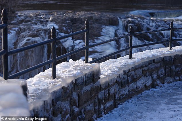
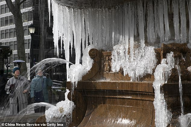
Meteorologists told Americans to prepare for significant ice accumulation that will cause power outages and ‘create treacherous driving conditions,’ especially across parts the Northeast.
Some schools and businesses throughout this region may be forced to delay openings Thursday morning due to hazardous travel conditions.
A few inches of snow could blanket northern states, with up to six inches of accumulation forecasted at higher elevations.
The heaviest snowfall will be concentrated across the Upper Midwest and Michigan‘s Upper Peninsula as well as parts of the interior Northeast, including New York and parts of New England.
The storm will begin battering the Eastern US Wednesday and persist into Thursday.
Residents of many states within its path have been told to use extreme caution when traveling by car and foot over the next two days.

‘Be prepared for slippery roads. Slow down and use caution while driving,’ the , according to the National Weather Service (NWS) warned.
‘If you are going outside, watch your first few steps taken on stairs, sidewalks, and driveways. These surfaces could be icy and slippery, increasing your risk of a fall and injury,’ the agency added.
The storm will get underway today, spreading a wintery mix of snow and ice across the Midwest.
This could ‘throw a wrench into travel plans for the middle of the week in some big cities such as Chicago, Detroit and Minneapolis,’ AccuWeather reported.
By Wednesday afternoon, the warmer side of this storm will spark ‘feisty’ thunderstorms in states further south, the forecasting network added.
As this mild air clashes with frigid air father north later today, the major ice storm will begin to take shape across a zone stretching from the Midwest to the Great Lakes, AccuWeather Meteorologist Brandon Buckingham warned.
Significant icing of a quarter-inch or more is expected to accumulate tonight mainly along and between the Interstates 70 and 80 in Michigan, Indiana and Ohio.
‘Hazardous travel would result from that freezing rain, which occurs when rain freezes on contact with any subfreezing surface,’ AccuWeather reported.

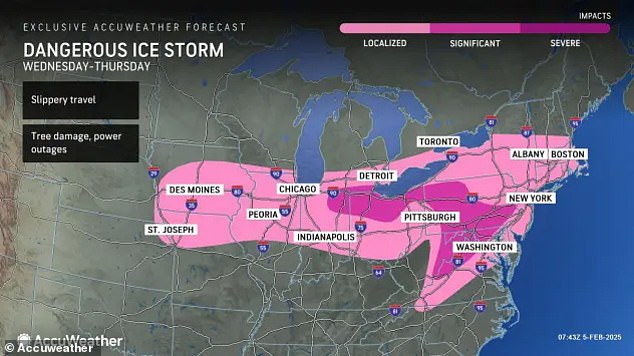
By Thursday, the ice threat will expand into expand into parts of the Appalachians, mid-Atlantic and Northeast.
‘The potential exists for dangerous amounts of ice accretion into Thursday,’ Buckingham said.
‘This poses a risk for tree damage and power outages as the storm moves through.’
The areas most at risk include part of the central Appalachians through Pennsylvania and southern New York, where up to half an inch of ice could accumulate.
Long-lasting power outages, downed tree limbs and ‘nearly impossible’ travel conditions could impact the cities of Cumberland, Maryland; Harrisburg, State College and Williamsport, Pennsylvania.
A shorter period of icing will mainly occur early in the day Thursday across a much larger area extending as far south and east as the I-95 corridor, making for a slippery morning commute.
This impact-zone includes Washington DC, Baltimore, Philadelphia, New York City and Boston.
Precipitation in these cities is expected to change over to rain as the storm persists Thursday, but snow will continue to fall further north.

Widespread snow accumulation of one two three inches are expected across northern New England, with up to half a foot possible in the higher elevations of northern New York, Vermont, New Hampshire and Maine.
New York City and Philadelphia could see a coating of snow.
Thunderstorms ‘strong enough to produce hail and dangerous winds’ are possible from Kentucky to Tennessee down into northern Mississippi and eastern Arkansas, said AccuWeather senior on-air meteorologist Ariella Scalese.
Cold, gusty winds of 40 to 50 miles per hour will trail behind the precipitation as this storm moves from the Mississippi Valley to the East Coast.
This could result in a ‘rash of additional hazards even after the icing is over,’ AccuWeather reported.
After some warmer weather earlier in the week, forecasters predict temperatures will plummet back back near or below the historical average for early February across much of the Northeast and Midwest as the storm moves toward the East Coast.
The Great Lakes should brace for wind gusts of 40 to 50 miles per hour Thursday before they move into the interior Northeast on Friday.
Wind gusts over 30 miles per hour are also possible across the Interstate 95 corridor of the Northeast Friday.
By the weekend, this storm will have moved offshore. But there is more severe winter weather to come in February, meteorologists warn.
‘We are monitoring three potential storms between Feb. 5-11,’ AccuWeather lead long-range forecaster Paul Pastelok said last month.
‘This will be a busy pattern with potential disruptions to travel and business.’
Another storm will be close behind this mid-week bout of snow and ice, impacting much of the same area from Friday through the weekend, according to AccuWeather.
Specific details on where this weekend storm is expected to hit are still to come, but meteorologists are already predicting more adverse conditions and travel delays.
